Fore River (Maine) on:
[Wikipedia]
[Google]
[Amazon]
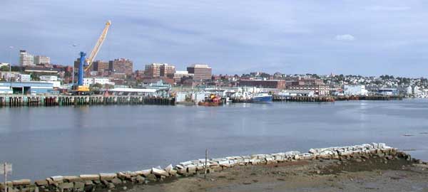
 The Fore River is a short horn-shaped
 The Fore River is a short horn-shaped
 estuary
An estuary is a partially enclosed coastal body of brackish water with one or more rivers or streams flowing into it, and with a free connection to the open sea. Estuaries form a transition zone between river environments and maritime environment ...
, approximately long, separating Portland
Portland most commonly refers to:
* Portland, Oregon, the largest city in the state of Oregon, in the Pacific Northwest region of the United States
* Portland, Maine, the largest city in the state of Maine, in the New England region of the northeas ...
and South Portland in Maine
Maine () is a state in the New England and Northeastern regions of the United States. It borders New Hampshire to the west, the Gulf of Maine to the southeast, and the Canadian provinces of New Brunswick and Quebec to the northeast and north ...
in the United States
The United States of America (U.S.A. or USA), commonly known as the United States (U.S. or US) or America, is a country primarily located in North America. It consists of 50 states, a federal district, five major unincorporated territorie ...
. Many of the port facilities of the Portland harbor are along the estuary, which is formed just southwest of Portland by the confluence of several creeks. The estuary was initially known as Levett's River, so named by the first English settler of the Casco Bay
Casco Bay is an inlet of the Gulf of Maine on the southern coast of Maine, New England, United States. Its easternmost approach is Cape Small and its westernmost approach is Two Lights in Cape Elizabeth. The city of Portland sits along its south ...
region, Capt. Christopher Levett
Capt. Christopher Levett (15 April 1586 – 1630) was an English writer, explorer and naval captain, born at York, England. He explored the coast of New England and secured a grant from the King to settle present-day Portland, Maine, the first ...
. But shortly afterwards, the estuary came to have the name by which it is known today.
The Stroudwater River flows into the Fore River estuary. The Cumberland and Oxford Canal
The Cumberland and Oxford Canal was opened in 1832 to connect the largest lakes of southern Maine with the seaport of Portland, Maine. The canal followed the Presumpscot River from Sebago Lake through the towns of Standish, Windham, Gorham, and ...
connected the estuary with Sebago Lake
Sebago Lake is the deepest and second-largest lake in the U.S. state of Maine. The lake is deep at its deepest point, with a mean depth of . It is possible that Sebago is the deepest lake wholly contained within the entire New England region, ...
via the Stroudwater River from 1832 through 1870. The estuary enters Casco Bay
Casco Bay is an inlet of the Gulf of Maine on the southern coast of Maine, New England, United States. Its easternmost approach is Cape Small and its westernmost approach is Two Lights in Cape Elizabeth. The city of Portland sits along its south ...
on the southeast edge of Portland. Like other coastal areas along the Gulf of Maine
The Gulf of Maine is a large gulf of the Atlantic Ocean on the east coast of North America. It is bounded by Cape Cod at the eastern tip of Massachusetts in the southwest and by Cape Sable Island at the southern tip of Nova Scotia in the northeast ...
, it experiences moderately high tides, and thus the water level in the estuary and the harbor varies greatly throughout the day, leaving mud flats at low tide. It is spanned by the Pan Am Railways
Pan Am Railways, Inc. (PAR) is a subsidiary of CSX Corporation that operates Class II regional railroads covering northern New England from Mattawamkeag, Maine, to Rotterdam Junction, New York. Pan Am Railways is primarily made up of former Clas ...
bridge and three highway bridges: the Casco Bay Bridge which connects Portland to South Portland, Veterans Memorial Bridge which carries Route 1, and a causeway which carries I-295 Interstate 295 is the designation for several Interstate Highways in the United States:
*Interstate 295 (Delaware–Pennsylvania), a bypass of Philadelphia, Pennsylvania
*Interstate 295 (Florida), a beltway around central Jacksonville
*Interstate 29 ...
.
References
Geography of South Portland, Maine Geography of Portland, Maine Rivers of Cumberland County, Maine Port of Portland (Maine) Rivers of Maine {{Maine-river-stub